Jim Lux 2026/03/07 10:57
One way to get phase measurements in a quasi near field setup (i.e. flying a
probe on a UAV) is to use GPS timing info.
Virtually every GPS module out there provides a 1pps tick, typically good to
some tens of ns, and much better over some time period. So you can do:
1) you can measure the receiver’s oscillators and post process to remove their
contribution. (easier said than done, but doable)
2) you can get accurate position and time of the recorded signals. 1ns, 30cm
is doable, especially if you simultaneously record at your base location (that
helps remove common mode ionospheric uncertainty in the GPS).
Unfortunately, a lot of the inexpensive SDRs (RTL-SDR - looking at you) have
no way to time tag the recorded data accurately.
One way to do this kind of thing is to fly a GPSDO with a programmable output
frequency (like the LeoBodnar units) - So you can generate a well known “in
band” tone that goes with your test signal. And, if you take the 1pps from
the GPSDO, and use that to modulate the tone, you can record a signal that
lets you extract the instantaneous phase. I’ve seen other schemes using UAVs
where they use some sort of beacon signal that has PN modulation.
I’ve done this (at work) with an array of 3 RTL-SDRs and a bucket load of post
processing in Matlab & Python. It would be WAY easier if the SDR did decent
time tagging (which has to be hardware.. the USB connection is non
deterministic) - essentially you need the ability to record synchronized
samples from the RF and the 1pps. The modulated in-band pilot tone is a hack.
(one with a long history - it’s been used at VLA and even earlier by Bracewell
at the Stanford radio observatory in the 1960s)
Granted, you’re not doing this with a single VNA. More a “virtual” VNA.
There was some work done by folks at JPL on measuring the pattern of the 9 MHz
sounding radar antenna on Europa Clipper using a UAV. Most of what JPL does is
published on JPL’s Open Repository (JOR). Look for Decrossas, Chahat, and
Miller as authors (not necessarily all on one paper).
And there’s a bunch of folks trying to make very precise pattern measurements
of array and element patterns for low frequency astronomy. Google for HERA UAV
Radiation Pattern Measurement. HERA is a low frequency array radio
telescope, you can also use MWA(Murchison Widefield Array), LOFAR (Low
Frequency Array ) and SKA (Square Kilometer Array), which are all working
towards similar goals.
> On Mar 7, 2026, at 09:12, Glenn n6gn via groups.io
<n6gn=sonic.net@groups.io> wrote:
>
>
>
>
> Your approach sounds reasonable though for higher directivity antenna
systems significantly involving an earth reflected path the far-field distance
gets too great for 'home use', at least at my house. (:>) My reason for
antenna measurement was to provide credibility for NEC2 modeling rather than
an exhaustive in situ measurement - as valuable as that would be. I was able
to achieve only slightly more than 100' separation between the traveling wave
antenna I was testing, given my available residential real estate
limitations. As the pending article (in DUBUS) describes, this fell
considerably short of 2D^2/lambda for the combined antenna&earth system even
at VHF.
>
>
>
> Except for physically 'small' structures having low directivity at HF or
significant gain in the VHF to microwave region, getting good data in the far
field over significant elevation becomes tough. In the US I'm not permitted to
fly my quadcopter higher than 400 feet AGL except with special dispensation.
Thus a straight 2-port VNA measurement with test cables and even amateur
aviation techniques become impractical.
>
>
>
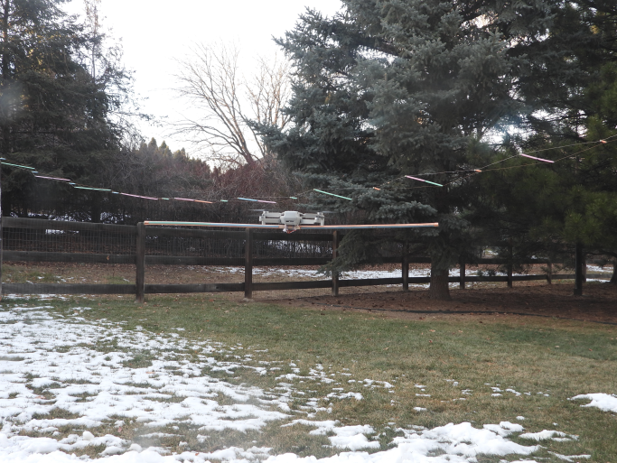
> My approach was to use only a scalar measurement, limited as it was, but
aided by quadcopter supporting a VHF dipole of known ERP and pattern. Here's a
pic of the quadcopter and horizontally polarized airborne 144 MHz source
hovering in front of a ~5 lambda VHF TWA. This really needed to be measured
in an open area of several acres which is something I don't have access to.
>
> <Screenshot from 2026-03-06 07-14-54.png>
>
>
>
> In order to get sufficient time/distance resolution it's important to have
wideband data. Simply measuring at an AUT's intended (narrowband) frequency
isn't useful to separate some kinds of common multi-path - recognizing that an
earth-ray is part of the antenna system for practical implementations.
>
>
>
> I guess it's no wonder that commercial antenna ranges, even those at VHF and
above, become tremendously expensive. At lower frequencies they seem to be
impossible except by using known, often ionospheric, signal sources. This is
a great value of the amateur and HamSci related WSPR and PSWS investigations.
But that's another story !
>
>
>
> Glenn n6gn
>
>
_._,_._,_
* * *
